Issued at 400 AM CDT Sat Oct 10 2026
000
WTNT44 KNHC 100845
TCDAT4

Post-Tropical Cyclone Isaias Discussion Number  15
NWS National Hurricane Center Miami FL       AL092026
400 AM CDT Sat Oct 10 2026

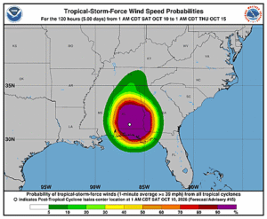
Isaias has very rapidly weakened over Alabama and has transitioned
into a post-tropical cyclone.  Satellite images show that all deep
convection has been scoured well northward away from the low-level
center, with a warm front extending eastward from the former
tropical cyclone.  Thus this is the last advisory on Isaias, with
an initial intensity of 30 kt set from surface observations.

The cyclone should move northward and north-northeastward this
weekend and gradually weaken as it moves across the Tennessee and
Ohio Valleys.  No significant changes were made to the track or
intensity forecasts, except lower wind speed on day 1.  Note there
is still a risk of some high wind gusts over the southern
Appalachians as the cyclone moves just to the west of those
mountains, along with the potential for heavy rain causing flash
floods.

This is the last tropical cyclone discussion issued by the National
Hurricane Center on this system.  Future information on this system
can be found in discussions issued by the Weather Prediction Center
beginning at 1000 AM CDT, under AWIPS header TCDAT4, WMO header
WTNT44 KWNH, and on the web at www.hurricanes.gov.

Rainfall forecasts for the United States are at:
https://www.wpc.ncep.noaa.gov/qpf/qpf2.shtml
and outlooks of flash flood risks can be found at
https://www.wpc.ncep.noaa.gov/qpf/excessive_rainfall_outlook_ero.php


Key Messages:

1. Heavy rainfall associated with the post-tropical remnants of
Isaias will be spreading quickly northward into the Tennessee
Valley, Southern Appalachians and Southeast today.  Considerable
flash and urban flooding will be possible. Landslides are also
possible across the Southern Appalachians.   Additional heavy rains
are possible across portions of Northwest Florida and heavy rains
are also possible across coastal Southwest Florida, resulting in
flash and urban flooding.

2. Post-storm safety:  Follow advice of local officials and avoid
areas of downed power lines and flooding. Ensure generators are
properly ventilated and placed outside at least 20 feet away from
dwellings and garages to avoid carbon monoxide poisoning. During
clean up, be careful when using chainsaws and power tools. Drink
plenty of water to avoid heat exhaustion.


FORECAST POSITIONS AND MAX WINDS

INIT  10/0900Z 32.0N  86.5W   30 KT  35 MPH...POST-TROPICAL
 12H  10/1800Z 33.7N  86.7W   25 KT  30 MPH...POST-TROP/INLAND
 24H  11/0600Z 35.2N  86.0W   25 KT  30 MPH...POST-TROP/INLAND
 36H  11/1800Z 37.6N  82.7W   20 KT  25 MPH...POST-TROP/INLAND
 48H  12/0600Z...DISSIPATED

$$
Forecaster Blake