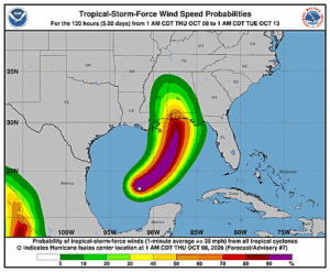
Issued at 400 AM CDT Thu Oct 08 2026
208
WTNT44 KNHC 080856
TCDAT4

Hurricane Isaias Discussion Number   7
NWS National Hurricane Center Miami FL       AL092026
400 AM CDT Thu Oct 08 2026

Right after the previous advisory, Air Force Reserve hurricane
hunter aircraft launched a dropsonde in the southwest quadrant of
the storm, finding a 150 m boundary layer average wind of 76 kt,
which was the basis for upgrading Isaias to a hurricane at 0330 UTC.
Since that time, a NOAA-P3 aircraft has taken over the in-situ
sampling of the hurricane, finding that Isaias continues to
intensify. The Tail Doppler Radar (TDR) swaths still indicate some
northward tilt with height, likely an impact of moderate westerly
vertical wind shear that continues to impinge on the circulation,
though the circulation is more aligned than in yesterday's mission.
The peak TDR winds were up to 80 kt on the 500 m level, and
experimental data that reduces the peak TDR winds to the 10 meter
level support a maximum sustained wind of 70 kt this advisory.

Aircraft fixes indicate that Isaias continues to maintain a
east-northeastward heading at 060/8 kt. The most critical steering
feature is a subtropical ridge centered east of the Bahamas that is
building westward, leading to an enhancement of environmental
southerly flow over the eastern Gulf. At the same time, a mid-level
trough stretched across the northern Gulf coast will be reinforced
by another impulse digging in from the Rocky Mountains, leading to a
more amplified short-wave over east Texas. The net effect of these
synoptic features should result in Isaias making a turn to the
northeast and the north over the next 24-48 h. The guidance this
cycle has not changed appreciably since the previous cycle, and
there continue to be across-track differences between the further
west physics-based models, and further east AI/Machine
Learning-based models. The NHC track forecast remains very close to
the prior one, and continues to lead more on the Google DeepMind
ensemble mean (GDMI) and HFIP Corrected Consensus Approach (HCCA)
track aids, which have been our best performing track guidance this
year.  As mentioned previously, after Isaias moves inland, the
guidance is showing a more subtle westward shift as Isaias is
captured by the short wave trough to its west, leading in the
formation of a potent cutoff low over the Tennessee valley as the
tropical cyclone becomes post-tropical.

The intensity forecast continues to be somewhat tricky. Isaias has
been trying to become better vertically aligned despite dealing with
around 20 kt of westerly vertical wind shear, and an eyewall keeps
coming and going in aircraft fixes. Other environmental factors (30
C sea-surface temperatures, sufficient deep-layer moisture) are
quite favorable. Because the shear is not forecast to increase
appreciably for the next 24 h, and because the hurricane has been
intensifying despite the shear, significant intensification is still
shown in the short-term, making Isaias just shy of major hurricane
intensity in 24 h. This part of the intensity forecast is on the
higher end of the guidance, close to the HCCA and GDMI intensity
aids. In the final 12-24 h before Isaias makes landfall on the north
Gulf coast, vertical wind shear ramps up to 40-50 kt, and this will
likely impart some weakening. However, at the same time, the
hurricane's wind field may become broader and more asymmetric as it
begins to interact with the short-wave trough capturing it from the
west. Regardless, Isaias is expected to remain a dangerous hurricane
through landfall, and gusty winds are expected well inland after
landfall given the anticipated expansion of the wind field and
accelerating forward speed of the storm.

Key Messages:

1. Isaias is expected to strengthen and be a strong hurricane when
it approaches the northern Gulf Coast on Friday. A life-threatening
storm surge is expected along a portion of the northern Gulf Coast,
and a Storm Surge Warning remains in effect from the Mouth of the
Mississippi River to Steinhatchee, Florida. Residents in the warning
area should follow advice given by local officials and evacuate if
told to do so.

2. Damaging hurricane force-winds are expected over portions of the
Florida Panhandle, southern Alabama, and southern Mississippi, and a
Hurricane Warning remains in effect from Ocean Springs, Mississippi
to the Bay/Gulf County Line, Florida. Residents in these areas
should prepare for the possibility of long-duration power outages.

3. Isaias will bring areas of heavy rainfall to the central U.S.
Gulf coast and much of the Southeast Friday into the weekend. Flash
and urban flooding, along with isolated river flooding, will be
possible.

4. Isaias could bring gusty winds and areas of heavy rain to the
western portion of the Yucatan Peninsula through today.


FORECAST POSITIONS AND MAX WINDS

INIT  08/0900Z 23.3N  91.2W   70 KT  80 MPH
 12H  08/1800Z 24.2N  90.0W   85 KT 100 MPH
 24H  09/0600Z 25.9N  88.6W   95 KT 110 MPH
 36H  09/1800Z 28.4N  87.6W   90 KT 105 MPH
 48H  10/0600Z 31.0N  87.6W   55 KT  65 MPH...INLAND
 60H  10/1800Z 33.7N  88.5W   30 KT  35 MPH...POST-TROP/INLAND
 72H  11/0600Z 36.0N  88.7W   25 KT  30 MPH...POST-TROP/INLAND
 96H  12/0600Z...DISSIPATED

$$
Forecaster Papin