Issued at 1100 PM AST Thu Aug 27 2026
000
WTNT44 KNHC 280244
TCDAT4

Tropical Storm Dolly Discussion Number   3
NWS National Hurricane Center Miami FL       AL042026
1100 PM AST Thu Aug 27 2026

Dolly appears to be more or less maintaining its intensity at this
time.  However, the associated deep convection is not very
well-organized, with no well-defined banding features evident on
satellite images.  The center of circulation is estimated to be on
the north side of the main area of convection.  The Dvorak
intensity estimate from TAFB remains at 35 kt.  There was a
Metop-B scatterometer pass from just before 00Z which showed just a
couple of 35-kt vectors.  Therefore the advisory intensity is kept
at 35 kt.  The scatterometer pass did not completely capture the
circulation of the storm but it did suggest some
north-northeastward to south-southwestward elongation of the center.

The storm continues to move quickly toward the west and the initial
motion estimate is 280/20 kt, about the same as before.  Dolly is
forecast to move mainly westward at a fast forward speed for the
next couple of days on the south side of a strong high pressure
ridge over the central Atlantic.  There have been no significant
changes in the track guidance from earlier today.  There is
fairly good agreement amongst the various model tracks, and the
official track forecast is roughly in the middle of these tracks.
This is close to the latest Google DeepMind solution.

Although it will encounter warmer ocean waters, Dolly is likely to
move into less favorable atmospheric conditions during the next
couple of days.  Some slight short-term strengthening is possible,
but increasing vertical wind shear, relatively dry air and the
fast forward motion of the system should begin to adversely affect
Dolly fairly soon.  The global models show the system degenerating
into a tropical wave while it approaches the Lesser Antilles, and
the NHC intensity forecast is close to the model consensus.
Post-tropical positions are provided at 48-60h given the risk of
gusty winds and heavy rainfall.

KEY MESSAGES:

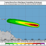
1. Heavy rains from Dolly or its remnants could affect the Leeward
Islands late Saturday into Sunday with possible impacts in the
Virgin Islands, Puerto Rico, and Hispaniola Sunday and Monday.  This
heavy rain may produce flash flooding, especially in areas of
higher terrain of the Leeward Islands.


FORECAST POSITIONS AND MAX WINDS

INIT  28/0300Z 13.8N  42.3W   35 KT  40 MPH
 12H  28/1200Z 14.3N  45.7W   40 KT  45 MPH
 24H  29/0000Z 15.2N  50.2W   40 KT  45 MPH
 36H  29/1200Z 16.0N  54.7W   40 KT  45 MPH
 48H  30/0000Z 16.7N  59.0W   35 KT  40 MPH...POST-TROPICAL
 60H  30/1200Z 17.0N  63.0W   30 KT  35 MPH...POST-TROP/REMNT LOW
 72H  31/0000Z...DISSIPATED

$$
Forecaster Pasch