Issued at 1000 AM CDT Wed Jun 17 2026
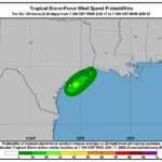
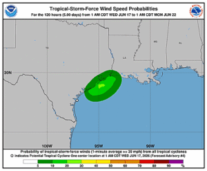
000
WTNT41 KNHC 171454
TCDAT1

Tropical Storm Arthur Discussion Number   5
NWS National Hurricane Center Miami FL       AL012026
1000 AM CDT Wed Jun 17 2026

The low pressure area near the Middle Texas coast has produced
sustained convection well to the east of its center this morning. A
1200 UTC TAFB Dvorak classification indicated enough convective
organization to designate the system as a sheared tropical cyclone.
Within the past hour or two, buoy observations and a ship report
have indicated tropical-storm-force winds occurring within this
convection. Additionally, Air Force Reserve Hurricane Hunters
investigating the storm found peak 850-mb flight-level winds up to
52 kt, which also suggest this system has reached tropical storm
intensity. Based on these findings, the system is designated as
Tropical Storm Arthur with an intensity of 35 kt.

Arthur is starting to accelerate northeastward (045/8 kt) within
strengthening southwesterly flow associated with a low- to mid-level
trough. There are no significant changes to the track forecast
reasoning, with a faster northeastward motion expected today that
will move the center of the system along or over the Texas coast
today and then farther inland over southeastern Texas and
southwestern Louisiana by tonight. With no major changes to the
track guidance this cycle, the updated NHC forecast is very similar
to the previous one.

Given the unrelenting westerly shear and Arthur's close proximity to
land, it seems unlikely that much additional strengthening will
occur. The tropical-storm-force winds are confined to the eastern
semicircle and mainly occurring over the offshore waters. Arthur
will likely maintain its intensity while it remains over water, and
then weaken by tonight once it moves inland. Global model fields
indicate it will open into a trough soon thereafter, and although a
24-h forecast point is included mainly for continuity purposes,
Arthur should dissipate before that time. There is still a signal in
the global models for low pressure development over the western
Atlantic late this week or this weekend as remnant vorticity from
Arthur emerge off the Southeast U.S. coast. The exact nature of this
low remains unclear, so we will continue to monitor model trends to
evaluate the potential for tropical cyclone formation.

Heavy rainfall and life-threatening flash flooding remain the
primary hazard with this system. Based on recent observations, the
Tropical Storm Warning has been extended westward along the Upper
Texas coast to High Island.


KEY MESSAGES:

1. Potentially life-threatening flash flooding and urban flooding
are likely through Friday across southern Louisiana, southern
Mississippi, southern Alabama, southwestern Georgia, and the Florida
Panhandle, with possible flooding near the Upper Texas coast.
Ongoing heavy rainfall could prolong the flood threat into the
weekend.

2. Tropical-storm-force winds are expected along the Upper Texas
and Louisiana coasts today from High Island to Morgan City where a
Tropical Storm Warning is in effect.

3. Minor to moderate coastal flooding is expected along portions of
the Upper Texas and Louisiana coastlines today.


FORECAST POSITIONS AND MAX WINDS

INIT  17/1500Z 28.6N  95.8W   35 KT  40 MPH
 12H  18/0000Z 30.0N  94.2W   30 KT  35 MPH...INLAND
 24H  18/1200Z 31.9N  91.6W   20 KT  25 MPH...POST-TROP/REMNT LOW
 36H  19/0000Z...DISSIPATED

$$
Forecaster Reinhart