Issued at 400 AM CDT Wed Jun 17 2026
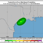
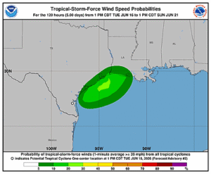
000
WTNT41 KNHC 170835
TCDAT1

Potential Tropical Cyclone One Discussion Number   4
NWS National Hurricane Center Miami FL       AL012026
400 AM CDT Wed Jun 17 2026

The center of the low pressure area is very near the Middle Texas
coast, and offshore buoy observations indicate that maximum winds
remain 25 kt.  A line of deep convection has formed over the
northwestern Gulf waters since the last advisory, but due to strong
westerly shear, this activity is located more than 120 n mi to the
east/southeast of the low-level center.  As a result, the latest
Dvorak classification from TAFB is Too Weak To Classify, meaning
the system does not have the convective organization necessary to
be designated as a tropical cyclone.

The current motion is northeastward, or 045/5 kt.  The system is
embedded in strengthening low- to mid-level southwesterly flow, and
with another trough approaching from the northwest, it is expected
to accelerate northeastward today.  The track guidance has shifted
slightly westward on this cycle, and the center of the low is
therefore likely to straddle the Texas coast for much of the day,
before moving farther inland over eastern Texas or Louisiana
tonight.  The NHC official track has been nudged westward, close to
the TVCN and HCCA consensus aids.

The prospects for this system to become a tropical cyclone may be
decreasing.  With the low-level center unlikely to fully emerge
over the Gulf waters for an appreciable amount of time, and 25-30
kt of westerly shear expected to continue for the next 12 hours, it
will be difficult for the system to gain the convective
organization necessary to become a tropical cyclone before it moves
inland tonight.  Even if the system doesn't become a tropical
cyclone, there could still be some strengthening of the wind field
well east of the center during the day, and the NHC official
forecast will continue to show a peak of 35 kt in 12 hours.  After
that, all of the global models now show the system opening up into a
trough over Louisiana by tonight.  The official forecast shows the
system as a remnant low at 24 hours, but it's entirely possible it
will have dissipated by then.

The global models show the remnant low-level vorticity continuing
eastward across the Southeast U.S. on Thursday and Friday, and the
ECMWF, Canadian, and UKMET models indicate that a low pressure
system could redevelop, especially once the system moves offshore
over the western Atlantic.  The exact nature of this low is unclear
at this time, but we will monitor model trends for the possibility
of tropical cyclone formation over the western Atlantic late this
week or this weekend.

Regardless of whether the system becomes a tropical cyclone, heavy
rainfall and life-threatening flash flooding will be the primary
hazards with this system.


KEY MESSAGES:

1. Potentially life-threatening flash flooding and urban flooding
are likely through Thursday across southern Louisiana, southern
Mississippi, southern Alabama, southwestern Georgia and the Florida
Panhandle, with possible flooding near the Upper Texas coast.
Ongoing heavy rainfall could prolong the flood threat into the
weekend.

2. Tropical-storm-force winds are expected along the Louisiana
coast today from Sabine Pass to Morgan City where a Tropical
Storm Warning is in effect.

3. Minor to moderate coastal flooding is expected along portions of
the Upper Texas and Louisiana coastlines today.


FORECAST POSITIONS AND MAX WINDS

INIT  17/0900Z 28.0N  96.7W   25 KT  30 MPH...POTENTIAL TROP CYCLONE
 12H  17/1800Z 29.1N  95.2W   35 KT  40 MPH...TROPICAL STORM
 24H  18/0600Z 31.1N  92.8W   25 KT  30 MPH...POST-TROP/REMNT LOW
 36H  18/1800Z...DISSIPATED

$$
Forecaster Berg