Issued at 1000 PM CDT Tue Jun 16 2026
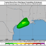
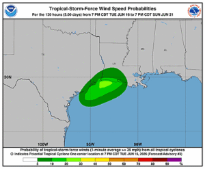
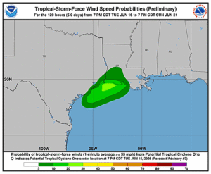
000
WTNT41 KNHC 170235
TCDAT1

Potential Tropical Cyclone One Discussion Number   3
NWS National Hurricane Center Miami FL       AL012026
1000 PM CDT Tue Jun 16 2026

The center of the system is beginning to emerge into the
northwestern Gulf.  Surface observations do not show very strong
winds over the area at this time, and the current intensity is held
at 25 kt.  This is consistent with a Dvorak classification from
TAFB.  There is significant westerly vertical wind shear over the
disturbance, with most of the deep convection displaced well away
from the center of the low.  Given that there has been no noticeable
increase in the deep convective organization of the disturbance, it
is being maintained as a potential tropical cyclone for this
advisory.

Based on the center fixes, the initial motion estimate, 050/5 kt, is
similar to that from the previous advisory. There has been little
change in the track model guidance.  The system is expected to
accelerate northeastward in the flow on the southern and
southwestern side of a broad mid-level trough over the eastern
United States.  The official forecast track shows the disturbance or
storm moving just offshore of, and parallel to, the Texas coast
during the next day or so.  Then the system is likely to go back
onshore late Wednesday or Wednesday night.  No significant change
has been made to the track forecast for this advisory, and the
official forecast is fairly close to the corrected consensus
solution.

The center should move far enough offshore on Wednesday for some
intensification to occur due to a combination of warm Gulf waters
and upper-level divergence.  However the SHIPS guidance diagnoses
fairly strong shear over the area during the next 24-36 hours which
should limit strengthening up to landfall.  The NHC forecast
continues to indicate the system becoming a tropical storm tomorrow,
which is also shown in the IVCN intensity model consensus.

Regardless of whether the system becomes a tropical cyclone, heavy
rainfall and life-threatening flash flooding will be the primary
hazards with this system.


KEY MESSAGES:

1. Potentially life-threatening flash and urban flooding is likely
through Thursday across Louisiana and southern Mississippi, and is
possible near the Upper Texas coast.  Flash flooding is also
possible across Alabama, Georgia, and the Florida Panhandle through
the end of the week.  Prolonged rainfall may extend the flood threat
into the weekend.

2. Tropical-storm-force winds are expected along the Louisiana
coast on Wednesday from Sabine Pass to Morgan City where a Tropical
Storm Warning is in effect.

3. Minor to moderate coastal flooding is expected along portions of
the Upper Texas and Louisiana coastlines.


FORECAST POSITIONS AND MAX WINDS

INIT  17/0300Z 27.6N  97.1W   25 KT  30 MPH...POTENTIAL TROP CYCLONE
 12H  17/1200Z 28.5N  95.6W   30 KT  35 MPH...TROPICAL CYCLONE
 24H  18/0000Z 30.2N  93.3W   35 KT  40 MPH...INLAND
 36H  18/1200Z 32.1N  90.9W   20 KT  25 MPH...INLAND
 48H  19/0000Z...DISSIPATED

$$
Forecaster Pasch/Adams