Issued at 1100 PM EDT Tue Sep 30 2025
020
WTNT44 KNHC 010244
TCDAT4

Hurricane Imelda Discussion Number  18
NWS National Hurricane Center Miami FL       AL092025
1100 PM EDT Tue Sep 30 2025

Satellite images show that Imelda has developed a ragged large eye
feature with deep convection wrapping around its western side.  The
strongest thunderstorms are currently confined to the northwest
quadrant.  Despite the structural change, the Air Force Hurricane
Hunters have found that the minimum pressure and maximum winds are
about the same as earlier.  Based on that data, the initial
intensity is held at 75 kt.  This estimate is notably above the
latest satellite estimates.

Imelda is starting to pick up some forward speed and continues to
bend to the right, with the latest motion estimated to be 070/12 kt.
A much faster east-northeast to northeast motion is expected soon
in the strong flow ahead of a large-scale trough, in which Humberto
is embedded within.  This motion should take the core of Imelda near
Bermuda Wednesday evening, but weather conditions there will likely
begin to deteriorate Wednesday afternoon.  After that, a turn to
the northeast over the open Atlantic is expected.  No significant
changes were made to the previous track forecast, and this one lies
near the middle of the guidance envelope.

Imelda is expected to strengthen overnight and Wednesday as the
hurricane approaches Bermuda.  The intensification will likely be
due to a combination of tropical and non-tropical forcing, and it
could become a category 2 hurricane when it is near the island. The
models suggest that Imelda will complete extratropical transition in
about two days when it merges with a mid- to upper-level trough and
the remnants of Humberto.  The system is expected to gradually decay
after the transition. Imelda is also expected to significantly grow
in size over the next few days, which will cause the ongoing high
surf and swells to persist over a large portion of the central and
western Atlantic.


KEY MESSAGES:

1. Imelda is expected to bring damaging hurricane-force winds when
it passes near or over Bermuda Wednesday afternoon or evening.  A
Hurricane Warning is in effect for the island.

2. Imelda is expected to produce heavy rainfall that could cause
flash flooding across Bermuda Wednesday into Thursday.  Large and
damaging waves are also expected on the island.

3. Swells and high surf from both Humberto and Imelda are expected
to produce dangerous marine conditions and rip currents along much
of the East Coast of the United States during the next several days.


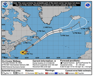
FORECAST POSITIONS AND MAX WINDS

INIT  01/0300Z 29.7N  73.9W   75 KT  85 MPH
 12H  01/1200Z 30.7N  70.9W   85 KT 100 MPH
 24H  02/0000Z 32.2N  65.7W   85 KT 100 MPH
 36H  02/1200Z 33.9N  60.0W   85 KT 100 MPH
 48H  03/0000Z 35.4N  54.4W   80 KT  90 MPH...POST-TROP/EXTRATROP
 60H  03/1200Z 37.9N  50.3W   70 KT  80 MPH...POST-TROP/EXTRATROP
 72H  04/0000Z 39.9N  48.2W   60 KT  70 MPH...POST-TROP/EXTRATROP
 96H  05/0000Z 45.4N  41.2W   50 KT  60 MPH...POST-TROP/EXTRATROP
120H  06/0000Z 51.6N  30.1W   40 KT  45 MPH...POST-TROP/EXTRATROP

$$
Forecaster Cangialosi


