Issued at 500 AM EDT Tue Sep 30 2025
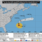
851
WTNT44 KNHC 300859
TCDAT4

Tropical Storm Imelda Discussion Number  15
NWS National Hurricane Center Miami FL       AL092025
500 AM EDT Tue Sep 30 2025

Deep convection has redeveloped on the western side of Imelda
during the past several hours, though a fair portion of the
circulation has been overtaken by dry air aloft.  The last reports
overnight from an Air Force Reserve Hurricane Hunter aircraft
indicate that the pressure had fallen again to 983 mb, with some
increase in flight-level winds as they exited in the western
quadrant.  Given the improved organization on satellite since the
plane left, I'm going to nudge the maximum winds up to 60 kt on
this advisory, and another Hurricane Hunter should be in the area
this morning.

Imelda has taken the long-awaited turn away from the mainland, now
estimated at 035/7 kt.  This general motion is expected today,
followed by a faster motion towards the east-northeast primarily
due to increasing mid-latitude southwesterly flow.  There remains
some speed differences in the models, but it is notable that all of
the guidance is near Bermuda between 36-48 h.  The new forecast is
a touch south of the previous one, perhaps reflecting some binary
steering influences from Humberto as the pair of tropical cyclones
get closer together.

The environment around Imelda is a complicated one, with lots of
shear and dry air in the vicinity while the system remains over
warm waters.  A recent AMSR pass also shows better low-level
structure, so intensification is forecast today.  Imelda should
experience a favorable trough interaction by Wednesday, forcing an
increase in the maximum winds as Imelda undergoes a protracted
extratropical transition with lots of upper divergence and
convection.  Every model forecasts a strong sting jet to form on
the south and west side of the cyclone on Wednesday during the
later stages of the transition.  The new forecast is near a mean of
the global and regional hurricane models, showing a potent system
near Bermuda.  Imelda probably won't have a conventional hurricane
structure near that island, but there is a significant risk of high
winds due to the hybrid tropical cyclone structure expected then.
Steady weakening is anticipated by late week after the system
passes Bermuda.


KEY MESSAGES:

1. Imelda is expected to intensify into a hurricane later today
with the cyclone approaching Bermuda during the day Wednesday as a
hurricane. A Hurricane Watch is in effect for the island of Bermuda
due to the expected onset of tropical storm conditions beginning
Wednesday afternoon.

2. Locally heavy rainfall across coastal sections of southeast
North Carolina could cause isolated flash and urban flooding
through tonight. As Imelda passes near Bermuda, 2 to 4 inches – 50
to 100 mm – of rainfall is expected from Wednesday into Thursday.

3. Swells and high surf from both Humberto and Imelda are expected
to produce dangerous marine conditions and rip currents along much
of the East Coast of the United States during the next several days.


FORECAST POSITIONS AND MAX WINDS

INIT  30/0900Z 28.8N  76.8W   60 KT  70 MPH
 12H  30/1800Z 29.3N  75.7W   65 KT  75 MPH
 24H  01/0600Z 30.3N  72.7W   70 KT  80 MPH
 36H  01/1800Z 31.6N  68.4W   80 KT  90 MPH
 48H  02/0600Z 32.8N  63.0W   85 KT 100 MPH
 60H  02/1800Z 34.4N  56.9W   75 KT  85 MPH...POST-TROP/EXTRATROP
 72H  03/0600Z 36.6N  51.8W   65 KT  75 MPH...POST-TROP/EXTRATROP
 96H  04/0600Z 41.5N  48.0W   55 KT  65 MPH...POST-TROP/EXTRATROP
120H  05/0600Z 48.0N  40.0W   45 KT  50 MPH...POST-TROP/EXTRATROP

$$
Forecaster Blake