Issued at 1100 PM EDT Fri Oct 24 2025
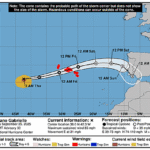
000
WTNT43 KNHC 250253
TCDAT3

Tropical Storm Melissa Discussion Number  15
NWS National Hurricane Center Miami FL       AL132025
1100 PM EDT Fri Oct 24 2025

Reports from NOAA and Air Force Reserve Hurricane Hunter aircraft
indicate that Melissa is still trying to get organized. While the
central pressure has fallen to 993 mb, the tail Doppler radar data
from the NOAA aircraft shows that the 500-mb center is displaced
about 20-25 n mi east-southeast of the surface center. The tilt is
also present at the aircraft flight levels, with dropsondes
released at the flight-level center missing the surface center and
reporting 25-35 kt surface winds. In addition, the aircraft radar
data and land-based radar data from Jamaica show that the cyclone
has not yet been able to develop a persistent eyewall. Based mainly
on the central pressure and satellite intensity estimates the
initial intensity is held at 55 kt.

Although the initial motion is a bit uncertain, Melissa now appears
to be moving slowly northwest with the initial motion 325/3 kt. A
turn toward the west or west-northwest and a continued slow forward
speed are expected in 12-24 h as low- to mid-level ridging builds
to the north of the cyclone. This motion should continue through
about 72 h. After that time, a deep-layer mid-latitude trough
moving into the southeastern United States and the southwestern
Atlantic will break the ridge to the north, with Melissa expected
to turn northward and eventually northeastward as it recurves into
the westerlies.  There remains a substantial spread in the guidance
with respect to where the center of Melissa may pass in relation to
Jamaica, with solutions ranging from the GFS passing near the
eastern end of the island to the Canadian passing west of the
island. The new forecast track is similar to the previous track and
shows the center passing over Jamaica just after 72 h. However, any
motion north of the current forecast track could bring the center
near or over Jamaica at almost any time between 24-72 h. After
passing Jamaica, Melissa is likely to move near or over eastern
Cuba, but which portion of eastern Cuba may be most affected
remains uncertain at this time.

While the westerly shear that has been affecting Melissa will not
completely stop during the next 2-3 days, it is forecast to
decrease to about 10-15 kt in 24 h or less. This should allow rapid
development as the storm is located in a moist environment over
very warm sea surface temperatures. The one short-term restraining
factor is that Melissa's structure is not quite good enough yet to
allow rapid intensification (RI), and thus it could be another
6-12 h before RI begins in earnest. The latest round of intensity
guidance shows somewhat lower peak intensities than the previous
advisory, mainly due to the models moving Melissa near or over
Jamaica. However, the current forecast track keeps the center
offshore for 72 h or more, and based on this the new intensity
forecast is at the high end of the guidance with a peak intensity
of 135 kt. Despite the weaker guidance, there is still a
possibility that Melissa could become a category 5 hurricane during
the forecast period. After passing near or over Jamaica, the cyclone
is forecast to weaken due to possible interaction with Cuba and
increasing southwesterly shear as Melissa encounters the
mid-latitude westerlies.


Key Messages:

1. Jamaica:  Melissa’s slow movement will bring a multi-day period
of damaging winds and heavy rainfall beginning late Saturday or
Sunday, likely causing catastrophic flash flooding and numerous
landslides.  There is an increasing risk of life-threatening storm
surge early next week. All preparations should be complete by late
Saturday.

2. Haiti:  Catastrophic flash flooding and landslides are expected
across southwestern Haiti into early next week, likely causing
extensive infrastructural damage and potentially prolonged isolation
of communities. Immediate preparations to protect life and property
are urged. Strong winds could also potentially last for a day or
more over the Tiburon peninsula.

3. Dominican Republic: Heavy rainfall could produce potentially
catastrophic flash flooding and numerous landslides in southern
regions.

4. Eastern Cuba, Bahamas, and the Turks and Caicos:  Monitor Melissa
closely.  There is an increasing risk of a significant storm storm
surge, damaging winds, and heavy rainfall by the middle of next
week. In eastern Cuba, the risk of life-threatening flash flooding
and landslides is increasing.


FORECAST POSITIONS AND MAX WINDS

INIT  25/0300Z 16.1N  74.9W   55 KT  65 MPH
 12H  25/1200Z 16.5N  75.2W   65 KT  75 MPH
 24H  26/0000Z 16.7N  75.7W   85 KT 100 MPH
 36H  26/1200Z 16.8N  76.2W  105 KT 120 MPH
 48H  27/0000Z 16.8N  76.8W  120 KT 140 MPH
 60H  27/1200Z 16.9N  77.5W  135 KT 155 MPH
 72H  28/0000Z 17.4N  77.6W  135 KT 155 MPH
 96H  29/0000Z 19.3N  76.6W  115 KT 130 MPH
120H  30/0000Z 23.2N  73.7W   90 KT 105 MPH

$$
Forecaster Beven