Issued at 1100 PM AST Tue Sep 23 2025
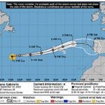
385
WTNT42 KNHC 240234
TCDAT2

Hurricane Gabrielle Discussion Number  29
NWS National Hurricane Center Miami FL       AL072025
1100 PM AST Tue Sep 23 2025

Gabrielle's eye became a little less distinct over the past several
hours, but the system continues to produce very cold-topped deep
convection to near -70 deg C.  Convective banding features remain
fairly well defined, although upper-level outflow is becoming a
little restricted over the western portion of the circulation.
The advisory intensity estimate is reduced just slightly to 110
kt, which is a blend of the latest CI and final Dvorak T-numbers
from TAFB and SAB.

The hurricane continues to pick up forward speed and the motion is
now around 065/19 kt.  The basic steering scenario remains about
the same as in the previous advisories.  Over the next few
days, Gabrielle should move between the subtropical ridge over the
central Atlantic and a large mid-latitude trough over the north
Atlantic.  This motion should take the system near or over the
Azores in about 60 hours.  The official track forecast is very
similar to the previous one and close to the corrected consensus
model guidance.

Drier air, increasing vertical wind shear, and cooling ocean waters
should cause the system to steadily weaken during the next several
days.  The only offsetting factor might be baroclinic interactions
with the nearby trough which could help Gabrielle maintain some of
its intensity while it moves near or through the Azores.  The
official intensity forecast is just slightly above the latest LGEM
guidance.

KEY MESSAGES:

1.  Gabrielle is forecast to approach the Azores late on Thursday as
a hurricane. A Hurricane Watch remains in effect for all of the
islands of the Azores, and interests there should closely monitor
Gabrielle's progress as hurricane conditions are possible later this
week.

2.  Swells generated by Gabrielle will continue to affect Bermuda,
the east coast of the United States from North Carolina northward
and Atlantic Canada during the next couple of days.  These swells
are likely to cause life-threatening surf and rip current
conditions. Please consult products from your local weather office.


FORECAST POSITIONS AND MAX WINDS

INIT  24/0300Z 35.1N  54.3W  110 KT 125 MPH
 12H  24/1200Z 35.6N  50.1W  100 KT 115 MPH
 24H  25/0000Z 36.1N  44.1W   90 KT 105 MPH
 36H  25/1200Z 36.9N  38.0W   80 KT  90 MPH
 48H  26/0000Z 38.4N  31.6W   70 KT  80 MPH
 60H  26/1200Z 40.1N  26.1W   60 KT  70 MPH
 72H  27/0000Z 41.5N  20.5W   55 KT  65 MPH...POST-TROP/EXTRATROP
 96H  28/0000Z 41.5N  13.5W   40 KT  45 MPH...POST-TROP/EXTRATROP
120H  29/0000Z 39.5N   9.5W   25 KT  30 MPH...POST-TROP/EXTRATROP

$$
Forecaster Pasch