Issued at 1000 AM CDT Tue Jun 16 2026
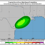
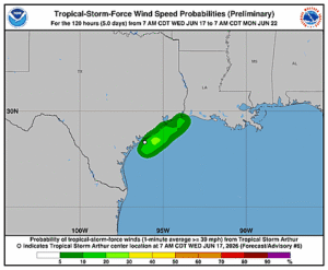
000
WTNT41 KNHC 161457
TCDAT1

Potential Tropical Cyclone One Discussion Number   1
NWS National Hurricane Center Miami FL       AL012026
1000 AM CDT Tue Jun 16 2026

The disturbance (AL90) that we have been tracking for several days
across the southern Gulf of America into northeastern Mexico has
moved into southern Texas.  While the system is producing plentiful
convection, it still lacks a well-defined center. However, most of
the guidance suggest that it will move offshore tonight, and winds
will increase to tropical-storm-force on Wednesday.  Thus,
advisories have been initiated on Potential Tropical Cyclone One,
and Tropical Storm Watches have been issued for portions of the
Upper Texas and southwestern Louisiana coasts. Regardless of
whether the system becomes a tropical cyclone, heavy rainfall and
life-threatening flash flooding will be the primary hazards
with this system. The initial intensity is set at 25 kt, based on
surface and radar data.

The system is moving slowly northeastward this morning.  We expect
the low to continue moving in that general direction with some
increase in forward speed due to it encountering faster flow
associated with a flat mid-latitude trough over the eastern United
States.  Model guidance hugs the Texas coast but generally keeps
it offshore for about a day on Wednesday before moving back onshore
late Wednesday or early Thursday.  The NHC forecast is between the
latest dynamical model consensus and the corrected-model consensus
HCCA.

The upper-level environment is not particularly conducive for much
intensification with a fair bit of shear and close proximity to
land.  However, there is enough upper-level support from a jet to
the north to cause large-scale deepening, along with convective
support from warm Gulf waters, so some intensification is
anticipated through Wednesday.  This forecast is similar to the
model consensus IVCN.  It should be noted that this system will
likely never have a pure tropical appearance on satellite due to the
upper trough and shear, with a highly asymmetric appearance with the
rainfall and winds favoring the eastern semicircle.


KEY MESSAGES:

1. Potentially life-threatening flash and urban flooding is possible
across the Texas coast eastward into central Mississippi through
Thursday. Prolonged rainfall may extend the flood threat into the
weekend. Widespread small stream and minor river flooding is
expected along the Texas coast into southwest Louisiana, with
isolated areas of significant river flooding possible across the
Texas Coast and Louisiana.

2. Potential Tropical Cyclone One is forecast to become a tropical
storm as it moves along or just off the northwestern Gulf coast
through Wednesday.  Tropical Storm Watches have been issued from
Sargent, Texas, to Morgan City, Louisiana.

3. Minor to moderate coastal flooding is expected along portions of
the Upper Texas and Louisiana coastlines.


FORECAST POSITIONS AND MAX WINDS

INIT  16/1500Z 27.0N  98.0W   25 KT  30 MPH...POTENTIAL TROP CYCLONE
 12H  17/0000Z 27.4N  97.2W   30 KT  35 MPH...POTENTIAL TROP CYCLONE
 24H  17/1200Z 28.2N  95.8W   35 KT  40 MPH...TROPICAL STORM
 36H  18/0000Z 29.6N  93.9W   35 KT  40 MPH
 48H  18/1200Z 31.6N  91.7W   25 KT  30 MPH...INLAND
 60H  19/0000Z...DISSIPATED

$$
Forecaster Blake