Issued at 1100 PM AST Wed Oct 01 2025
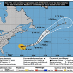
000
WTNT44 KNHC 020251
TCDAT4

Hurricane Imelda Discussion Number  22
NWS National Hurricane Center Miami FL       AL092025
1100 PM AST Wed Oct 01 2025

Data from the Air Force Reserve reconnaissance aircraft this evening
found that Imelda is likely in the early to mid stages of
extratropical transition. In addition to the aircraft crossing a
baroclinic zone just to the north of the hurricane's core, the winds
have become very asymmetric, with hurricane-force winds around the
western and southeastern sides of the circulation, but much lighter
winds to the northeast. The aircraft also found rising pressure
between fixes, and the earlier eyewall reported from the prior
mission has been reduced to a small fragment on the northwestern
side. Despite the degraded presentation, the 700 mb flight-level
winds were a little higher than the prior mission, peaking at 98 kt
in the southeastern quadrant. While this would normally translate to
a somewhat higher 90 kt maximum sustained wind, these flight-level
winds occurred where Imelda has little in the way of precipitation
according to the Bermuda radar. Thus, the initial intensity will
remain 85 kt for this advisory, using a slightly lower surface wind
reduction.

Aircraft fixes and Bermuda radar imagery indicate that Imelda
continues to accelerate quickly to the east-northeast, with its
estimated motion now at 075/25 kt. This motion will likely take the
hurricane's inner eyewall fragment right over the island of Bermuda
over the next couple of hours. The strongest winds associated with
Imelda are likely to be felt just after the center passes by,
thanks to the increasingly asymmetric wind-field of the hurricane.
In fact, the global and hurricane-regional models show a distinct
sting-jet like signature on the backside that both 18 UTC HAFS-A/B
and the 12 UTC ECMWF show moving directly over Bermuda between now
and the 06 UTC time frame. After passing Bermuda, the global and
regional-hurricane models show the hurricane completing
extratropical transition as the frontal boundary merges in with the
cyclone's core. The NHC intensity forecast is a little lower than
the prior advisory, but remains in good agreement with the consensus
aids HCCA/IVCN.

After Imelda clears Bermuda and becomes fully extratropical, the
models are in better agreement about the cyclone turning
northeastward by late Thursday or Friday when it fully phases with a
digging shortwave trough located upstream of the system. While
significant model spread persists, the 18 UTC GFS has come into
better agreement with the other global model guidance showing this
phasing solution rather than being left behind the trough. The
latest NHC track forecast this evening is roughly a blend of the
HFIP corrected consensus aid (HCCA) and the faster Google DeepMind
ensemble mean (GDMI).


KEY MESSAGES:

1. Imelda's core is currently near Bermuda and is expected to bring
damaging hurricane-force winds and large and damaging waves to
Bermuda as it moves over the island now into early Thursday.
Significant hurricane-force gusts are likely across Bermuda even
after the center passes.

2. Heavy rainfall could cause flash flooding across Bermuda tonight
into Thursday.

3. Swells and high surf from Imelda are expected to produce
dangerous marine conditions and rip currents along much of the East
Coast of the United States and the western Atlantic during the next
several days.


FORECAST POSITIONS AND MAX WINDS

INIT  02/0300Z 32.1N  65.0W   85 KT 100 MPH
 12H  02/1200Z 32.8N  60.7W   80 KT  90 MPH...POST-TROP/EXTRATROP
 24H  03/0000Z 34.0N  55.0W   65 KT  75 MPH...POST-TROP/EXTRATROP
 36H  03/1200Z 36.2N  51.3W   60 KT  70 MPH...POST-TROP/EXTRATROP
 48H  04/0000Z 38.6N  49.4W   55 KT  65 MPH...POST-TROP/EXTRATROP
 60H  04/1200Z 41.4N  47.3W   50 KT  60 MPH...POST-TROP/EXTRATROP
 72H  05/0000Z 44.5N  43.7W   45 KT  50 MPH...POST-TROP/EXTRATROP
 96H  06/0000Z 49.5N  34.0W   45 KT  50 MPH...POST-TROP/EXTRATROP
120H  07/0000Z 51.2N  28.0W   40 KT  45 MPH...POST-TROP/EXTRATROP

$$
Forecaster Papin