Issued at 500 PM AST Tue Sep 30 2025
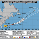
000
WTNT43 KNHC 302040
TCDAT3

Hurricane Humberto Discussion Number  25
NWS National Hurricane Center Miami FL       AL082025
500 PM AST Tue Sep 30 2025

Deep convection has persisted in the northeast quadrant through the
day and is now partially obscuring the low-level circulation.  An
afternoon AMSR2 microwave satellite pass showed curved band wrapping
around eastern semicircle of the hurricane.  Given the slightly
improved satellite presentation and the earlier aircraft data, the
initial intensity remains at 70 kt. The wind radii have been updated
based on a couple scatterometer passes from 1339 and 1500 UTC.

Humberto has turned northward and is moving an estimated 15 kt as
the hurricane nears the mid-latitude trough to its north.  Later
today, the cyclone is expected to turn northeast and on Wednesday to
the east-northeast in the westerly flow.  Only minor updates have
made to the latest NHC track forecast, which lies on the leading
edge of the track guidance envelope.

Model guidance suggests Humberto should gradually weaken while it
merges with the mid- to upper-level trough during the next day or
so. Humberto's dissipation has once again been moved up based on
recent model trends, now at 36 h.  While the official intensity
forecast shows Humberto becoming an extratropical cyclone on
Wednesday, the European model is showing the potential that it could
retain deep organized convection up until the cyclone becomes
elongated and loses its closed surface circulation.  The hurricane
is producing a large area of hazardous marine conditions over the
western and central Atlantic, where life-threatening rip currents
are expected to affect beaches throughout the region through the
week.

KEY MESSAGES:

1. Dangerous marine conditions, including high surf and
life-threatening rip currents, will continue to affect beaches of
the northern Caribbean, Bahamas, Bermuda, and much of the east coast
of the United States through the week.


FORECAST POSITIONS AND MAX WINDS

INIT  30/2100Z 34.0N  69.5W   70 KT  80 MPH
 12H  01/0600Z 35.3N  68.3W   65 KT  75 MPH
 24H  01/1800Z 36.1N  65.0W   60 KT  70 MPH...POST-TROP/EXTRATROP
 36H  02/0600Z...DISSIPATED

$$
Forecaster Bucci