Issued at 1100 PM EDT Wed Oct 29 2025
000
WTNT43 KNHC 300256
TCDAT3

Hurricane Melissa Discussion Number  35
NWS National Hurricane Center Miami FL       AL132025
1100 PM EDT Wed Oct 29 2025

Melissa is starting to re-intensify.  A large convective burst
continues near the center, albeit stretched from northeast to
southwest.  An Air Force Reserve Hurricane Hunter aircraft found
that the pressure has fallen a few mb to 970 mb, with increased
maximum 700-mb flight-level wind to 100 kt.  While normally this
would support closer to 90-kt surface winds, those strong winds
were over 75 n mi from the center well away from the central core.
This typically signifies a lower-than-standard wind reduction, so
the initial intensity is set to 85 kt on this advisory.

The hurricane is moving faster tonight, with microwave and
aircraft fixes resulting in an initial motion estimate of 030/18
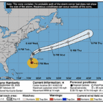
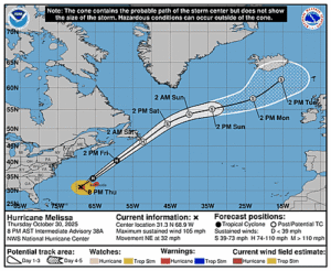
kt. Melissa is forecast to greatly accelerate during the next
two days due to steering flow between a trough moving through
the southeastern United States and a mid-level ridge over the
central Atlantic.  This should cause the hurricane to move away
from the Central Bahamas on Thursday morning and to the northwest
of Bermuda Thursday night.  The fast track continues into Friday,
with the then post-tropical Melissa forecast to move near the
Avalon Peninsula of Newfoundland as the calendar turns to November.
Only a slight westward adjustment was made to the NHC forecast,
near the Google DeepMind and HFIP Corrected Consensus models.

Melissa has a short window of time to intensify during the next day
or so as it remains over warm waters with moderate shear.  While
the shear greatly increases on Halloween along with cooling waters,
the forecast speed of the cyclone also jumps up along with upper-
level divergence from an approaching trough, which could lessen
the weakening rate.  Extratropical transition is anticipated in
about 48 hours due to very strong shear and cold waters.  The new
NHC intensity forecast is close to the previous one, remaining on
the high side of the guidance.


Key Messages:

1. Bahamas and the Turks and Caicos: Hurricane conditions,
life-threatening storm surge, and heavy rainfall are expected across
portions of the southeastern and central Bahamas through overnight.
Remain sheltered until local officials deem it safe to venture out.
Tropical storm conditions, heavy rains, and significant storm surge
are expected in the Turks and Caicos Islands through overnight.

2. Bermuda: Hurricane conditions are expected in Bermuda beginning
late Thursday and continuing through Thursday night.

3. Post-storm safety:  Follow advice of local officials as you may
need to remain sheltered after the storm due to downed power lines
and flooded areas.  Ensure generators are properly ventilated and
placed outside at least 20 feet away from dwellings and garages to
avoid carbon monoxide poisoning. During clean up, be careful when
using chainsaws and power tools. Drink plenty of water to avoid heat
exhaustion.


FORECAST POSITIONS AND MAX WINDS

INIT  30/0300Z 24.3N  74.3W   85 KT 100 MPH
 12H  30/1200Z 26.9N  72.4W   90 KT 105 MPH
 24H  31/0000Z 31.7N  68.2W   90 KT 105 MPH
 36H  31/1200Z 37.6N  62.2W   75 KT  85 MPH
 48H  01/0000Z 44.0N  55.5W   65 KT  75 MPH...POST-TROP/EXTRATROP
 60H  01/1200Z 50.0N  49.0W   60 KT  70 MPH...POST-TROP/EXTRATROP
 72H  02/0000Z 53.0N  43.0W   55 KT  65 MPH...POST-TROP/EXTRATROP
 96H  03/0000Z 56.5N  29.5W   45 KT  50 MPH...POST-TROP/EXTRATROP
120H  04/0000Z 57.5N  25.0W   40 KT  45 MPH...POST-TROP/EXTRATROP

$$
Forecaster Blake


