Issued at 500 PM EDT Mon Sep 29 2025
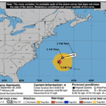
000
WTNT44 KNHC 292053
TCDAT4

Tropical Storm Imelda Discussion Number  13
NWS National Hurricane Center Miami FL       AL092025
500 PM EDT Mon Sep 29 2025

Since the prior advisory, Imelda's structure on satellite imagery
continues to improve. Curved bands are now wrapping around the
western side of the tropical storm's circulation, and the last few
fixes from the NOAA and Air Force Reserve Hurricane Hunters did show
enhanced winds wrapping around the western side, becoming more
symmetric, though some northward tilt with height was still
persisting on the last Tail Doppler Radar (TDR) swath from the
NOAA-P3 aircraft. Satellite intensity estimates have continued to
gradually rise since that time, so the initial intensity is being
raised to 55 kt this advisory, in best agreement with the SAB
subjective Dvorak fix of T3.5/55-kt and the latest SATCON intensity
estimate of 54 kt.

Imelda continues to move northward, estimated at 360/8 kt. This
motion should continue through tonight, but as Humberto erodes the
steering influence of a subtropical ridge east of Bermuda, the
cyclone is expected to make a sharp turn to the east-northeast as
the storm steering becomes dominated by the deep-layer trough that
is digging southward upstream of Imelda. The latest track guidance
trajectory is quite similar to the prior cycle, though it has once
again shifted a bit faster beyond 36 h. There also remains a
substantial amount of along-track spread in both the deterministic
and ensemble guidance this afternoon. The NHC track forecast is a
little faster than the prior cycle, once again attempting to blend
the HCCA and Google DeepMind ensemble mean (GDMI). Based on the
forecast track, tropical storm conditions are expected to begin on
the Island of Bermuda in about 48 h, and in response, the Bermuda
Weather Service has issued a Hurricane Watch for the island this
advisory.

Further intensification is expected over the next several days as
Imelda remains in a low to moderate vertical wind shear environment
along with sufficient mid-level moisture and warm sea-surface
temperatures above 28 C. In 48-60 h, the shear starts quickly
increasing, but a favorable trough interaction may temper this
negative factor initially. This interaction may enhance the winds
along the cyclone's western flank, as seen in the most recent set of
hurricane-regional model runs. These enhanced winds may then evolve
into a "sting jet" like feature as the system becomes extratropical
in the 60-72 h time frame. The exact timing of this transition
remains difficult to forecast, since the cyclone will still be under
fairly warm SSTs at 60-72 h. The official intensity forecast is on
the high side of the guidance envelope, but near the HCCA consensus
aid.


KEY MESSAGES:

1. Imelda is expected to intensify into a hurricane on Tuesday with
the cyclone approaching Bermuda during the day Wednesday as a
hurricane. A Hurricane Watch is now in effect for the island of
Bermuda due to the expected onset of tropical storm conditions
beginning Wednesday afternoon.

2. Tropical storm conditions are expected to continue for another
few hours on Great Abaco and Grand Bahama island in the northwestern
Bahamas.

2. Rainfall associated with Tropical Storm Imelda will continue to
impact the Bahamas through tonight, which may produce flash and
urban flooding.  Locally heavy rainfall across the coastal Carolinas
could cause isolated flash and urban flooding through tonight.

3. Swells and high surf from both Humberto and Imelda are expected
to produce dangerous marine conditions and rip currents along much
of the East Coast of the United States during the next several days.


FORECAST POSITIONS AND MAX WINDS

INIT  29/2100Z 27.7N  77.3W   55 KT  65 MPH
 12H  30/0600Z 28.4N  76.8W   65 KT  75 MPH
 24H  30/1800Z 29.3N  75.0W   70 KT  80 MPH
 36H  01/0600Z 30.4N  72.2W   75 KT  85 MPH
 48H  01/1800Z 31.7N  67.8W   80 KT  90 MPH
 60H  02/0600Z 33.3N  62.3W   85 KT 100 MPH
 72H  02/1800Z 35.0N  56.8W   75 KT  85 MPH...POST-TROP/EXTRATROP
 96H  03/1800Z 39.0N  50.0W   55 KT  65 MPH...POST-TROP/EXTRATROP
120H  04/1800Z 43.7N  47.6W   45 KT  50 MPH...POST-TROP/EXTRATROP

$$
Forecaster Papin