Issued at 500 PM EDT Sun Sep 28 2025
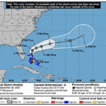
000
WTNT44 KNHC 282053
TCDAT4

Tropical Storm Imelda Discussion Number   9
NWS National Hurricane Center Miami FL       AL092025
500 PM EDT Sun Sep 28 2025

In the last outbound northeast leg, the Air Force reconnaissance
flying through the system found 850 mb flight level winds of 43 kt,
high enough to support upgrading Tropical Depression 9 to Tropical
Storm Imelda at the 18 UTC intermediate advisory. On that last fix,
a dropsonde launched in the center had a 1000 mb pressure, but with
a 34 kt surface wind gust that could be related to a nearby
convective feature, and a 998 mb pressure is used as the minimum
pressure. The initial intensity remains at 35 kt this advisory,
which is on the low side of the mean of the satellite estimates,
which range from 35-45 kt.

A more established motion with Imelda appears to finally be occuring
this afternoon, due northward at 360/8 kt. A general northward
motion is expected to continue over the next day or so as southerly
steering persists from both an upper trough over the southeastern
United States and the subtropical ridge centered just east of
Bermuda. After that period of time, the subtropical ridge's steering
influence decreases as Hurricane Humberto's larger outer circulation
creates a large weakness. The end result of this pattern change is
that Imelda is now forecast to turn sharply east-northeastward into
this weakness, starting on Tuesday and continuing through the
remainder of the forecast period, following behind Humberto. The
track guidance this cycle has finally started to stabilize near the
previous forecast track, though is still a tick faster than the
previous forecast cycle, and quite a bit of along-track spread
remains in the 4-5 day time frame. The NHC track forecast lies in
between the GFS and ECMWF track solutions, closest to but not quite
as fast as the Google DeepMind ensemble mean (GDMI).

Imelda's structure is gradually becoming better organized, with more
curvature in the convective bands on its eastern side, though the
earlier burst closer to the center has waned. Assuming a better
developed core forms soon, low to moderate vertical wind shear
between 15-20 kt, warm 28-30 C sea-surface temperatures, and
sufficient mid-level moisture should promote steady intensification
over the next 2-3 days. In 3-4 days, the cyclone is expected to find
itself in the right entrance region of an intensifying upper-level
jet, and the enhanced upper-level divergence in that time may help
support additional intensification even as the shear begins to
increase at this period. After the system passes Bermuda, a strong
baroclinic zone is expected to interact with the system, resulting
in extratropical transition by day 5 as it gets tangled up with a
frontal boundary. However, as stressed previously, this is a low
confidence forecast at long range given the recent large track
changes. In fact, simulated satellite imagery from the 12 UTC ECMWF
still suggests Imelda may produce significant convective bursts
while still over warm ocean waters in the day 4-5 forecast period.


KEY MESSAGES:

1. Imelda is expected to strengthen and bring tropical storm
conditions to portions of the central and northwestern Bahamas
through Monday.

2. Rainfall associated with Tropical Storm Imelda will continue to
impact eastern Cuba and the Bahamas through Tuesday, which will
likely produce flash and urban flooding.  Mudslides are possible in
the higher terrain.  Heavy rainfall across the coastal Carolinas
could cause isolated flash, urban, and river flooding through
Tuesday.

3. The risk of significant wind impacts along the southeastern
United States coast is decreasing, but interests in that area should
continue to monitor the latest forecast updates.

4. Swells and high surf from both Humberto and Imelda are expected
to produce dangerous marine conditions and rip currents along the
east coast of Florida and the Georgia coast through Monday.  These
conditions are expected to spread northward along much of the east
coast of the United States early this week.


FORECAST POSITIONS AND MAX WINDS

INIT  28/2100Z 24.2N  77.3W   35 KT  40 MPH
 12H  29/0600Z 25.5N  77.4W   45 KT  50 MPH
 24H  29/1800Z 27.2N  77.4W   55 KT  65 MPH
 36H  30/0600Z 28.4N  77.2W   60 KT  70 MPH
 48H  30/1800Z 29.2N  75.8W   65 KT  75 MPH
 60H  01/0600Z 29.8N  73.9W   70 KT  80 MPH
 72H  01/1800Z 30.7N  70.7W   80 KT  90 MPH
 96H  02/1800Z 31.8N  63.2W   80 KT  90 MPH
120H  03/1800Z 33.5N  58.5W   65 KT  75 MPH...POST-TROP/EXTRATROP

$$
Forecaster Papin