Issued at 500 PM EDT Fri Sep 26 2025
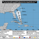
000
WTNT44 KNHC 262040
TCDAT4

Potential Tropical Cyclone Nine Discussion Number   1
NWS National Hurricane Center Miami FL       AL092025
500 PM EDT Fri Sep 26 2025

Visible satellite images and surface observations suggest that
Invest 94L is gradually organizing and beginning to develop a
low-level circulation near eastern Cuba with estimated maximum winds
of about 30 kt.  Although the system does not meet the criteria of a
tropical cyclone currently, it is expected to become one during the
next day or so.  In addition, the system is likely to bring tropical
storm conditions to portions of the central and northwestern Bahamas
this weekend and potential impacts to portions of the southeast U.S.
early next week.  Therefore, NHC is now initiating Potential
Tropical Cyclone advisories for this disturbance.

The system has been moving west-northwestward at about 8 kt during
the past 12 to 24 hours.  However, this motion is expected to change
as the disturbance is forecast to turn northward in southerly flow
between a large-scale trough over the eastern U.S. and a subtropical
ridge over the central-western Atlantic.  This track should take the
system across the central and northwestern Bahamas over the weekend.
The models are in good agreement through that time period, but they
diverge significantly early next week when the synoptic pattern
becomes complicated.  If the system moves on the fast side of the
guidance, it will likely be more influenced by the U.S. trough that
is expected to cut off.  In that scenario, the disturbance would
move inland over the southeast U.S. early next week.  Conversely, if
the system moves on the slow side of the guidance, Humberto's
circulation will cause the steering currents to collapse, resulting
in this system stalling near the southeast coast or drifting
eastward.  The NHC track forecast lies roughly between these
scenarios, in best agreement with EMXI, but confidence is very
low in the days 4 and 5 positions.

Strengthening is likely to be slow in the short term due to the
current land interaction and some southerly shear.  However, gradual
intensification seems like a good bet this weekend and on Monday
while the system tracks over the Gulf Stream and within a diffluent
upper-level wind pattern.  The NHC intensity forecast lies close to
the hurricane regional and consensus models and shows the system
reaching hurricane strength early next week.  It should be
emphasized that the long-range intensity forecast depends largely on
where the system is and the degree of land interaction at those
periods, and therefore, is of low confidence. Given the
higher-than-usual uncertainty in the forecast track and intensity of
the system, NOAA Hurricane Hunter aircraft have been collecting data
over the western Atlantic since yesterday, and additional upper-air
launches are occurring.  This data collection will continue through
the weekend to help improve the model guidance for this system.

KEY MESSAGES:

1. The disturbance is forecast to become a tropical storm this
weekend and bring tropical storm conditions to portions of the
central and northwestern Bahamas, where Tropical Storm Warnings and
Watches, respectively, have been issued. Rainfall associated with
this system will impact eastern Cuba, Hispaniola, Jamaica, and the
Bahamas through the weekend.

2.  There is an increasing threat of heavy rainfall early next
week from coastal Georgia through the Carolinas and into the
southern Mid-Atlantic states, which could cause flash, urban, and
river flooding.

3. The system is expected to be at or near hurricane intensity
when it approaches the southeast U.S. coast early next week, where
there is a risk of storm surge and wind impacts. Residents in that
area should monitor updates to the forecast and ensure they have
their hurricane plan in place.

FORECAST POSITIONS AND MAX WINDS

INIT  26/2100Z 20.9N  74.6W   30 KT  35 MPH...POTENTIAL TROP CYCLONE
 12H  27/0600Z 21.7N  75.3W   30 KT  35 MPH...POTENTIAL TROP CYCLONE
 24H  27/1800Z 22.7N  75.8W   30 KT  35 MPH...TROPICAL CYCLONE
 36H  28/0600Z 24.1N  76.4W   35 KT  40 MPH
 48H  28/1800Z 25.6N  76.9W   45 KT  50 MPH
 60H  29/0600Z 27.4N  77.3W   55 KT  65 MPH
 72H  29/1800Z 29.7N  78.0W   65 KT  75 MPH
 96H  30/1800Z 31.8N  78.9W   65 KT  75 MPH
120H  01/1800Z 32.3N  79.3W   60 KT  70 MPH

$$
Forecaster Cangialosi