Issued at 500 AM AST Fri Sep 26 2025
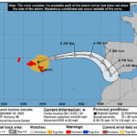
629
WTNT43 KNHC 260843
TCDAT3

Hurricane Humberto Discussion Number   7
NWS National Hurricane Center Miami FL       AL082025
500 AM AST Fri Sep 26 2025

Humberto has become better organized during the past several hours.
Conventional satellite imagery has shown a growing central dense
overcast, with hints of an eye-like feature near the center.
Microwave imagery revealed a well-defined rain band wrapping around
a vertically-aligned vortex, suggesting the developing of an
eyewall.  Satellite classifications have risen notably on this
cycle and the initial intensity is set to 65 kt, closest to the
TAFB Dvorak and SATCON estimates.

The hurricane is drifting slowly in weak steering currents with an
estimated motion of 320/3 kt.  Model guidance is in relatively good
agreement, showing Humberto gradually increasing speed while moving
west-northward to northwestward along the southern side of a
subtropical ridge during the next few days.  By early next week, the
hurricane is expected to turn northward around the westward
periphery of the high and begin accelerating northeastward.  Only
minor adjustments have been made to the latest official track
forecast.

Humberto is showing signs of steady-to-rapid intensification.  The
hurricane is over warm waters and seems to be experiencing less
vertical wind shear than the global models are currently suggesting.
Statistical rapid intensity indicators, such as DTOPS, are showing
elevated probabilities of a 25 to 30 kt increase in the next 24
hours.  Given these probabilities and the recent increase in initial
intensity, the NHC intensity forecast has been increased,
particularly in the near-term forecast, and lies above most of the
guidance.  By the middle of the forecast period, it is closer the
the corrected consensus aid, HCCA, and still shows Humberto becoming
a major hurricane this weekend.


FORECAST POSITIONS AND MAX WINDS

INIT  26/0900Z 22.2N  57.3W   65 KT  75 MPH
 12H  26/1800Z 22.3N  57.8W   80 KT  90 MPH
 24H  27/0600Z 22.6N  59.0W   90 KT 105 MPH
 36H  27/1800Z 22.9N  60.5W  100 KT 115 MPH
 48H  28/0600Z 23.5N  62.5W  110 KT 125 MPH
 60H  28/1800Z 24.5N  64.2W  115 KT 130 MPH
 72H  29/0600Z 26.0N  66.0W  115 KT 130 MPH
 96H  30/0600Z 29.7N  68.8W  100 KT 115 MPH
120H  01/0600Z 33.7N  67.8W   85 KT 100 MPH

$$
Forecaster Bucci