Issued at 500 PM AST Thu Sep 25 2025
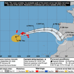
019
WTNT43 KNHC 252037
TCDAT3

Tropical Storm Humberto Discussion Number   5
NWS National Hurricane Center Miami FL       AL082025
500 PM AST Thu Sep 25 2025

Humberto continues to gradually gain strength over the central
Atlantic.  Deep convection has been increasing over the center, and
the cloud pattern is more symmetric than it was earlier today.  This
is an indication that the wind shear around the storm is lessening.
Recent microwave images indicate that an inner core appears to be
forming, and an earlier ASCAT pass showed maximum winds of about 45
kt.  Based on the improving satellite presentation, the initial
intensity is increased to 50 kt.  This value is also near the
average of the latest satellite intensity estimates.  The 34-kt wind
radii have been adjusted based on the ASCAT data.

Steady to rapid strengthening is expected during the next few days
as the storm moves into a more favorable environment of light winds
aloft and high moisture.  Given that Humberto is relatively compact
and an increasingly symmetric system, these conditions should cause
it to become a hurricane on Friday and a major hurricane over the
weekend. Less favorable environmental conditions should cause some
weakening early next week.  This prediction remains in line with the
latest HCCA and IVCN consensus models.

The storm has jogged a little to the north today, but the overall
motion is northwestward at 5 kt. Humberto remains embedded in weak
steering currents on the south side of a narrow and weak subtropical
high over the central Atlantic.  This pattern should keep the storm
moving slowly to the west-northwest or northwest during the next day
or two.  After that time, Humberto is expected to become
increasingly steered by a much stronger high over the western
Atlantic, which should cause the storm to accelerate.  The NHC track
forecast is a little slower than the previous one, trending toward
the latest consensus and Google Deep Mind models. This forecast
keeps Humberto over the open central and western subtropical
Atlantic during the next several days.


FORECAST POSITIONS AND MAX WINDS

INIT  25/2100Z 21.9N  57.0W   50 KT  60 MPH
 12H  26/0600Z 22.3N  57.4W   60 KT  70 MPH
 24H  26/1800Z 22.5N  58.0W   70 KT  80 MPH
 36H  27/0600Z 22.7N  59.1W   80 KT  90 MPH
 48H  27/1800Z 23.0N  60.8W   90 KT 105 MPH
 60H  28/0600Z 23.6N  62.7W  100 KT 115 MPH
 72H  28/1800Z 24.6N  64.7W  105 KT 120 MPH
 96H  29/1800Z 28.0N  68.2W  105 KT 120 MPH
120H  30/1800Z 31.6N  69.9W   90 KT 105 MPH

$$
Forecaster Cangialosi