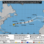
Issued at 500 AM AST Tue Sep 23 2025
000
WTNT42 KNHC 230849
TCDAT2

Hurricane Gabrielle Discussion Number  26
NWS National Hurricane Center Miami FL       AL072025
500 AM AST Tue Sep 23 2025

Gabrielle remains an impressive hurricane in satellite imagery.
However, it appears to have reached peak intensity, as the eyewall
convective tops have become more asymmetric during the past few
hours and the eye has become less distinct. This is likely due to
the onset of moderate southwesterly vertical shear as shown by the
restricted outflow in the southwestern quadrant. The various
subjective and objective satellite intensity estimates are in the
115-125 kt range, so the initial intensity is held at 120 kt.

The hurricane continues moving northeastward or 045/11 kt. Gabrielle
should continue to move around the northwestern side of the
mid-level subtropical ridge during the next 12-24 h and then
accelerate east-northeastward in the southern portion of the
mid-latitude westerlies.  A slight turn to the northeast ahead of a
higher-latitude trough is expected in 72-96 h, followed by a more
eastward motion as Gabrielle merges with the trough.  The guidance
envelope has only minor changes since the last advisory. So, the new
forecast, which lies near or just north of the consensus models, is
close to the previous forecast through 60 h and a little south of it
after that time. The new forecast is also a little faster than the
previous forecast.

Gradual weakening is expected during the next 24 h due to shear and
gradually decreasing sea surface temperatures along the forecast
track.  After that, increasing shear and even cooler water should
cause a faster weakening. While the above-mentioned trough could
provide enhanced divergence aloft which could help Gabrielle
maintain some of its intensity, it is also likely to cause Gabrielle
to start extratropical transition in about 60 h.  This transition
will likely be complete just after the cyclone passes the Azores.
The new intensity forecast is nudged downward from the previous
forecast and is in good agreement with the intensity consensus.


KEY MESSAGES:

1.  Swells generated by Gabrielle will continue to affect Bermuda,
the east coast of the United States from North Carolina northward,
as well as Atlantic Canada, during the next couple of days.  These
swells are likely to cause life-threatening surf and rip current
conditions. Please consult products from your local weather office.

2.  Gabrielle is forecast to approach the Azores late on Thursday.
Interests in the Azores should monitor the progress of Gabrielle
though it is too soon to specify the magnitude of potential wind,
rainfall, and wave impacts.


FORECAST POSITIONS AND MAX WINDS

INIT  23/0900Z 33.2N  59.7W  120 KT 140 MPH
 12H  23/1800Z 34.2N  57.3W  115 KT 130 MPH
 24H  24/0600Z 35.2N  52.7W  110 KT 125 MPH
 36H  24/1800Z 35.8N  47.0W  100 KT 115 MPH
 48H  25/0600Z 36.3N  40.7W   90 KT 105 MPH
 60H  25/1800Z 37.9N  34.0W   80 KT  90 MPH
 72H  26/0600Z 39.7N  28.5W   70 KT  80 MPH
 96H  27/0600Z 43.3N  19.8W   55 KT  65 MPH...POST-TROP/EXTRATROP
120H  28/0600Z 42.7N  13.2W   40 KT  45 MPH...POST-TROP/EXTRATROP

$$
Forecaster Beven