Issued at 500 PM AST Thu Sep 18 2025
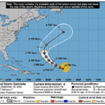
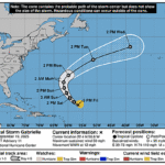
560
WTNT42 KNHC 182053
TCDAT2

Tropical Storm Gabrielle Discussion Number   7
NWS National Hurricane Center Miami FL       AL072025
Issued by the NWS Weather Prediction Center College Park MD
500 PM AST Thu Sep 18 2025

Gabrielle continues to fight off strong westerly vertical
wind shear and significant dry air entrainment this afternoon.
Some thunderstorms have blossomed on the storm's eastern flank,
which is an improvement from its naked low-level swirl earlier this
morning. The initial intensity is held at 45 kt based on recent
scatterometer data of at least 40 kt and little in the way of
change to its structure from earlier this morning.

Atmospheric conditions are expected to remain hostile for another
day or so, meaning Gabrielle is likely maintain its current
intensity or weaken slightly during that time. Recent 12Z guidance
indicates vertical wind shear relaxes and an increasingly moist
vertical profile should foster a much improved environment for
strengthening this weekend, with the GFS model trending toward the
more conducive ECMWF solution. As a result, intensity guidance is
notable higher on this cycle.  The NHC intensity forecast is raised
from the previous one, but not as high as the model consensus
mostly due to continuity. There are a growing number of hurricane
models that are indicating Gabrielle could approach major hurricane
strength after the weekend.

Gabrielle is moving west-northwestward at 13 kt and should maintain
this track with a bend toward the northwest over the next few days
as the storm is steered primarily by a subtropical ridge over the
central Atlantic.  A turn toward the north and northeast is
forecast to occur late this weekend and early next week when
Gabrielle rounds the western periphery of the ridge and a frontal
system approaches from the west.  While the guidance envelope has
shrunk on this forecast cycle, there are some significant speed
differences, with the ECMWF/GFS models considerably faster than the
Google Deep Mind ensemble.  Although no significant changes to the
forecast were made, confidence remains on the lower side given the
along-track model spread and an unclear intensity forecast beyond
48 hours. Interests in Bermuda should continue to monitor Gabrielle
over the next several days.


FORECAST POSITIONS AND MAX WINDS

INIT  18/2100Z 20.8N  52.7W   45 KT  50 MPH
 12H  19/0600Z 21.5N  54.2W   40 KT  45 MPH
 24H  19/1800Z 22.6N  56.3W   40 KT  45 MPH
 36H  20/0600Z 23.9N  58.1W   45 KT  50 MPH
 48H  20/1800Z 25.3N  59.8W   50 KT  60 MPH
 60H  21/0600Z 27.1N  61.1W   55 KT  65 MPH
 72H  21/1800Z 29.0N  62.0W   65 KT  75 MPH
 96H  22/1800Z 33.0N  61.0W   85 KT 100 MPH
120H  23/1800Z 39.0N  52.5W   80 KT  90 MPH

$$
Forecaster Mullinax/Blake